Shadow Lake Association Mission
The Mission of the Association shall be to collaborate with lake residents, the Town of Glover, and the State of Vermont, to learn, educate and foster best management practices around Shadow Lake, in order to preserve and promote the healthy ecology of the lake and to ensure pristine water quality for the benefit of current and future generations.
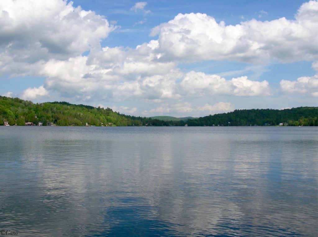
Shadow Lake is a beautiful, clear, natural, freshwater 210-acre lake. It supports cold water fishing, has very low nutrient concentrations and is 139 feet deep. There is a Vermont Department of Fish and Wildlife public boat launch, Glover town public swim beach, about 109 seasonal and year-round homes, with an active lake association supported by a friendly community.
Shadow Lake is located just off VT Route 16, in the Town of Glover, in Orleans County which is in the Northeast Kingdom (NEK) region of Vermont. The NEK area encompasses almost 1/5 of the State with over 200 lakes and ponds. Glover has two incorporated villages, Glover and West Glover and two lakes of considerable size – Shadow Lake (210 acres) and Lake Parker (221 acres, in W. Glover) and several ponds – Daniel’s Pond (120 acres), Clark’s Pond (a.k.a Tildy’s Pond) and Sweeney’s Pond.
The Town of Glover was chartered in 1783, to General John Glover who served in the Revolutionary War and with his group of associates acquired 23,040 acres of land after the war. In the year of 1860, Glover town population was 1,250. In year 2020, the population statistics are 1114.
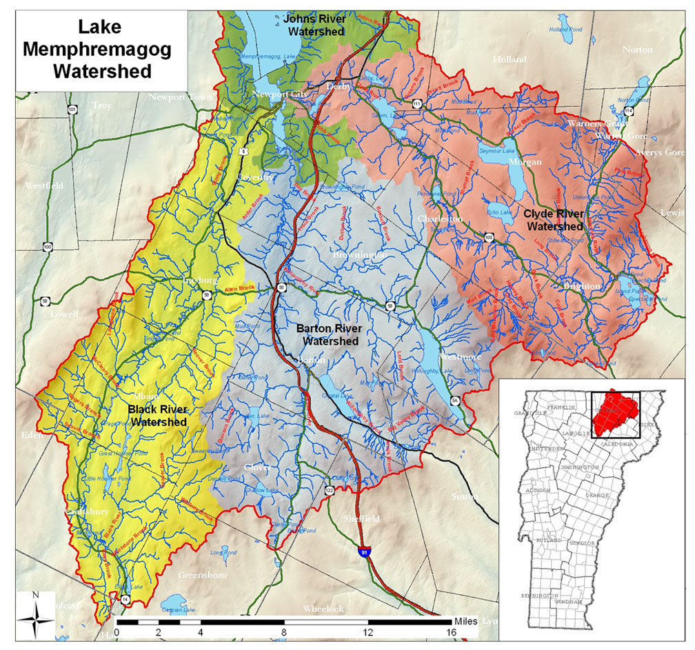
Shadow Lake is part of the Basin 17 Lake Memphremagog Watershed. Shadow Lake drains into the Barton River running northward through Glover to Lake Memphremagog which is shared with the province of Quebec, Canada. The majority of the lake is in Quebec while the majority of the lake’s watershed is in Vermont.
Physical Information:
Vermont State statistics show the Shadow Lake watershed/basin drainage area is 3575 acres or 5.6 square miles. Click here to view.
Shadow Lake is at an elevation of 1396 feet (425m) above sea level.
Lake area is 210 acres (8 hectares)
Maximum depth is 139 feet (42m)
Mean depth is 55 feet (16m)
Volume is 16,820 acre-feet – a 2019 VTDEC calculation using the 2018 bathymetry data obtained by VTDEC staff via the “biobase” tool.
Shoreline total area measures approximately 2.58 miles or 4.09 kilometers
1973 lake contour map from the state
2019 lake bathymetric map from VTDEC
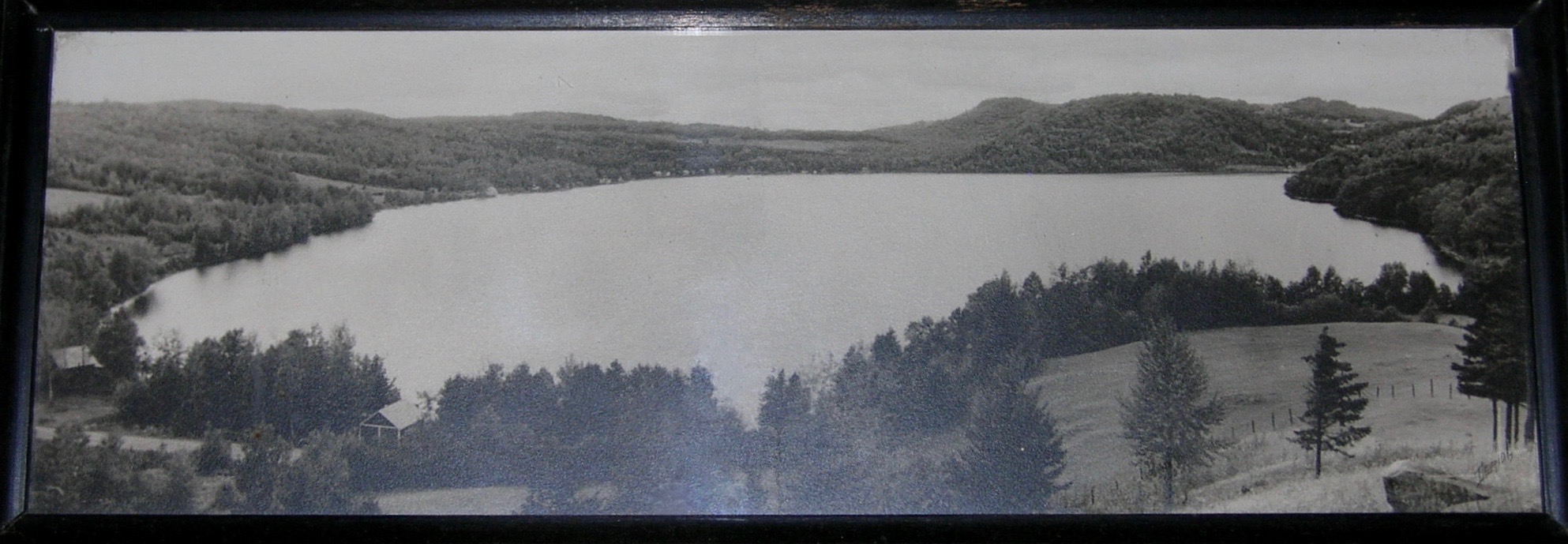
The highest elevation is the Black Hills, at 2,258 feet (688 m). Photo below.

The lake supports many native aquatic plants and fish – Brook, Brown, Rainbow and Lake Trout, Landlocked Salmon, Yellow Perch, Smallmouth Bass, and Panfish species. There are many birds that nest on the lake including Kingfishers and migrating birds like Loons, Ospreys, an occasional Great Blue Heron, and Bald Eagle. There are also small mammals, such as otters, raccoons, and minks.
Below are a few interesting tidbits of history borrowed from a 1998 book by Marilyn R. Walcott, (a fellow Shadow Lake summer resident) entitled, ‘Shadow Lake Reflections’. This book is about the Shadow Lake beginnings and the many remembrances conveyed from the people who have loved this lake and enjoyed their cottages over the years.
- Shadow Lake has gone under at least six name changes. Esther M. Swift wrote in Vermont Place Names (the Stephen Green Press’s, Brattleboro, VT, 1977.) The Abenaki name for the lake was ‘Pekdabowk’, meaning “smoke pond”. The earliest settlers called the lake Chambers Pond, Silver Lake, Eli Grey Lake, and for almost 100 years the lake was called Stone Pond until it was renamed Shadow Lake in 1922.
- When Shadow Lake was known as Stone Pond, on Oct 4,1899 a U.S. hatchery station was erected. The then Comissioner placed 40,000 land locked salmon in the pond.
- In the late 1800’s and early 1900’s there was a settlement at the end of Stone Pond (today Shadow Lake) near the outlet called “Slab City” in what was then called South Glover.

- The earliest camp building along the shoreline began in the late 1890’s but only 15 cottages were constructed before 1920. Today 109 cottages/residents dot the lake shore.
- The public beach was established in 1939 and is located at 1212 Shadow Lake Road, Glover, VT. The beach is a very popular summer gathering place for local people and tourists alike, to enjoy the clean water and scenic beauty of the lake.
- Vermont Department of Fish and Wildlife began stocking fish at Shadow Lake in the 1960’s.
- In 1959-60 a VT State Fishing Access was developed on land purchased from Theodore Kambour, R.K. Lang and E.K. Sableski. The access was upgraded in 1991.
For more information contact the Glover Historical Society.
The first organizational meeting of the Shadow Lake Improvement Association was held in 1947. In 1960 a reorganization took place and the name became The Shadow Lake Association, Inc. (SLA) Our Association is a member-supported non-profit 501(c)(4) tax exempt organization dedicated to improving the understanding and management of Shadow Lake for its long-term environmental health. The current By-laws were adopted in 1980, and 2016 Revisions were passed at the Annual Shadow Lake Association Meeting on July 8, 2017.
The members of the SLA are individuals and families who live around the lake. Our members are full time residents, seasonal residents and week-end residents. Some own lake front property, some own property with lake rights and some are community members or visitors who just love the lake.
Our pressurized, hot water boat wash was established in 2003. It was the only one like it until 2015 when others replicated it. It is conveniently located at the State Fishing Access.
Other History
Lay Monitoring: State program was established in 1979 to conduct periodic lake water quality sampling and this continues today.
Vermont Invasive Patroller: State program that monitors for aquatic invasive species, began at Shadow Lake in 2014.
Both of these programs are monitored by volunteers from Shadow Lake.
